

Google’s new AlphaEarth Foundations AI isn’t a satellite. It’s a system designed to make satellites themselves a lot less indispensable. Instead of waiting for orbital flyovers and stitching together uneven, sometimes cloudy datasets, AlphaEarth Foundations builds a persistent, unified model of the Earth’s surface and coastal waters. Think of it as a “virtual satellite” that can see more clearly, more consistently, and in some ways more accurately than traditional space-based sensors (Source: Google Deepmind).
A fascinating use of AI
This is way more than your grandpa’s Google Earth

The color-coded, information-dense imaging representing Alphaearth Foundations’ advanced mapping.
At its core, AlphaEarth Foundations integrates petabytes of Earth observation data — from radar and optical satellites to 3D lidar mapping and climate models — into what Google calls a global embedding. This embedding condenses massive datasets into uniform, easy-to-use summaries that describe the planet in 10-by-10-meter squares. The end result is a digital Earth twin that’s compact enough to analyze at scale, but rich enough to track changes in land use, vegetation health, and even coastal dynamics.
Where satellites stumble, AlphaEarth Foundations steps in. The team behind the model showed off examples in Ecuador, where persistent cloud cover has historically made agricultural monitoring nearly impossible. AlphaEarth was able to cut through the noise, mapping farmland in different stages of development without waiting for clear skies. In Antarctica, a nightmare scenario for most orbiting imagers due to irregular coverage and low light, the model rendered surface features in crisp detail. In Canada, it exposed subtle agricultural land-use changes invisible to conventional satellite imaging.
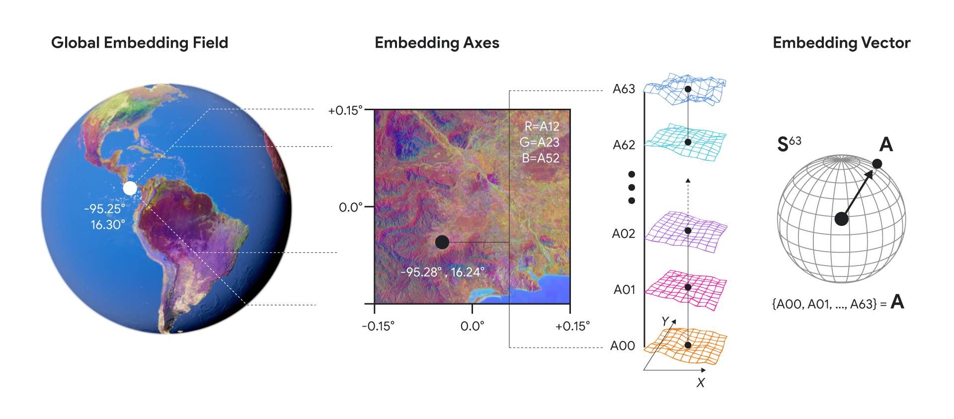
Each embedding consists of 64 dimensions. Taken as a whole, they cover the entire globe.
The model doesn’t just produce prettier maps. Its technical efficiency matters just as much. According to Google, the embeddings require 16 times less storage than comparable AI systems, making them cheap to use at planetary scale. In head-to-head testing, AlphaEarth Foundations delivered a 24% lower error rate than other leading AI mapping models, even when label data was scarce. That kind of efficiency translates directly into faster, more accurate decision-making for scientists and policymakers.
And the tech isn’t locked behind a corporate wall. Google is releasing a massive set of AlphaEarth embeddings — over 1.4 trillion footprints per year — through the Google Earth Engine as the Satellite Embedding dataset. More than 50 organizations, including the United Nations Food and Agriculture Organization, Stanford University, and Brazil’s MapBiomas project, have already put the system to work.

Examples of how embeddings take into accout data from various sources and timeframes.
The use cases are real and immediate. The Global Ecosystems Atlas is using the dataset to classify minimally or unmapped ecosystems such as hyper-arid deserts and coastal shrublands — data critical for conservation planning. In Brazil, MapBiomas is leveraging the embeddings to monitor agricultural expansion and deforestation in the Amazon, generating faster and more precise insights than traditional methods.
Nick Murray, Director of the Global Ecology Lab at James Cook University, called the dataset “revolutionary” for ecosystem mapping. MapBiomas founder Tasso Azevedo said it enables “maps that are more accurate, precise, and fast to produce, [which is] something we would have never been able to do before.”
Long term, AlphaEarth could be paired with reasoning LLMs like Google’s Gemini to unlock even more advanced geospatial intelligence. For now, though, the system represents a seismic shift in Earth observation: a move from relying on the timing and limits of satellites to a constantly updated, AI-driven view of the planet. If AlphaEarth Foundations delivers on its early promise, the future of global monitoring may not orbit above us — it may already be here.